 vesseltracker.com
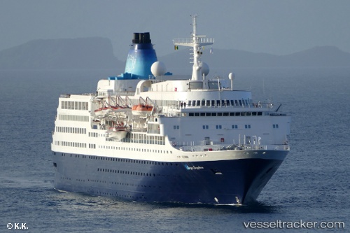
 BLUE SAPPHIRE
Current Status
Where is the vessel?
BLUE SAPPHIRE is currently in Near PYTHAGOREIO, based on AIS data received about 1h ago.
Latest AIS update:
Current position: 37.68103° N, 26.94921° E (Near PYTHAGOREIO)
Average speed (last 7 days): Loading…
Average speed (last 30 days): Loading…
Vessel profile: BLUE SAPPHIRE is a Passengers Ship with dimensions m x m.
This page combines live AIS, route history, probable destination signals, nearby traffic, and port activity for practical vessel monitoring.
The current position of vessel BLUE SAPPHIRE is 37.68103 lat / 26.94921 lng. Updated: 2026-04-21 19:28:30 UTCNearest reference points:
- Near PYTHAGOREIO
- Near KUSADASI
- Near FOURNI
Currently sailing under the flag of Saint Kitts and Nevis ![]()
Details:
Live Vessel BLUE SAPPHIRE Analytics (details, animations, etc.)
Recent AIS points (UTC):
2026-04-21 16:58:26 UTC · 37.68167, 26.94833 · SOG 0 kn · COG -1°2026-04-21 17:43:11 UTC · 37.68112, 26.94907 · SOG 0 kn · COG 217°
2026-04-21 19:28:30 UTC · 37.68103, 26.94921 · SOG 0 kn · COG 223°
2026-04-21 19:28:30 UTC · 37.68103, 26.94921 · SOG 0 kn · COG 223°