 vesseltracker.com
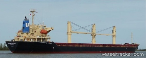
Atlantic Fairy
Current StatusWhere is the vessel?
Atlantic Fairy is currently in 263 nm SW of Lukovica pri Domzalah, based on AIS data received about 1h ago.
Latest AIS update:
Current position: 42.89039° N, 148.41951° W (263 nm SW of Lukovica pri Domzalah)
Average speed (last 7 days): Loading…
Average speed (last 30 days): Loading…
Vessel profile: Atlantic Fairy is a Bulk Carrier with dimensions 27m x 170m.
This page combines live AIS, route history, probable destination signals, nearby traffic, and port activity for practical vessel monitoring.
The current position of vessel Atlantic Fairy is 42.89039 lat / -148.41951 lng. Updated: 2026-04-10 01:31:57 UTCNearest reference points:
- Open sea, approx. 402 nm off the nearest listed port
- Open sea, approx. 410 nm off the nearest listed port
- Open sea, approx. 406 nm off the nearest listed port
Details:
Live Vessel Atlantic Fairy Analytics (details, animations, etc.)
Recent AIS points (UTC):
2026-04-09 23:36:46 UTC · 42.90331, -148.86108 · SOG 11.4 kn · COG 35°2026-04-09 23:36:46 UTC · 42.90331, -148.86108 · SOG 11.4 kn · COG 35°
2026-04-10 01:31:57 UTC · 42.89039, -148.41951 · SOG 10.9 kn · COG 110°
2026-04-10 01:31:57 UTC · 42.89039, -148.41951 · SOG 10.9 kn · COG 110°