 vesseltracker.com
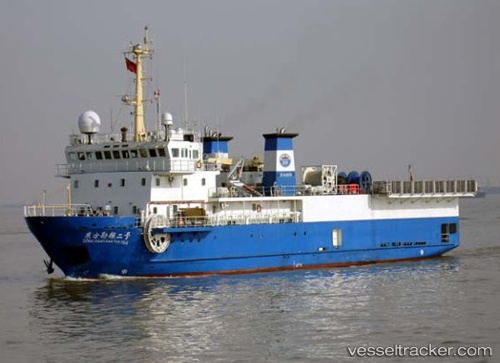
 DONG FANG KAN TAN NO. 2
Current Status
Where is the vessel?
DONG FANG KAN TAN NO. 2 is currently in 28 nm SW of Soroosh (Cyrus) Terminal, based on AIS data received about 1h ago.
Latest AIS update:
Current position: 28.79453° N, 49.00786° E (28 nm SW of Soroosh (Cyrus) Terminal)
Average speed (last 7 days): Loading…
Average speed (last 30 days): Loading…
Vessel profile: DONG FANG KAN TAN NO. 2 is a Research Vessel with dimensions 18m x 65m.
This page combines live AIS, route history, probable destination signals, nearby traffic, and port activity for practical vessel monitoring.
The current position of vessel DONG FANG KAN TAN NO. 2 is 28.79453 lat / 49.00786 lng. Updated: 2026-04-18 12:13:00 UTCNearest reference points:
- 25 nm W of Soroosh (Cyrus) Terminal
- 19 nm SW of Soroosh (Cyrus) Terminal
- 31 nm S of Soroosh (Cyrus) Terminal
Currently sailing under the flag of Panama ![]()
DONG FANG KAN TAN NO. 2 built in 2006 year
Deadweight:
650 tDetails:
Live Vessel DONG FANG KAN TAN NO. 2 Analytics (details, animations, etc.)
Recent AIS points (UTC):
2026-04-18 04:58:00 UTC · 28.82210, 48.93456 · SOG 1.6 kn · COG 126°2026-04-18 08:22:59 UTC · 28.78476, 49.04426 · SOG 1.8 kn · COG 97°
2026-04-18 10:01:49 UTC · 28.77199, 49.07506 · SOG 0.4 kn · COG 335°
2026-04-18 12:13:00 UTC · 28.79453, 49.00786 · SOG 1.8 kn · COG 300°