 vesseltracker.com
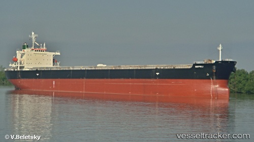
 KHALEJIA ANA 7
Current Status
Where is the vessel?
KHALEJIA ANA 7 is currently in 25 nm W of Hulaylah Terminal, based on AIS data received less than 1h ago.
Latest AIS update:
Current position: 26.01330° N, 55.46878° E (25 nm W of Hulaylah Terminal)
Average speed (last 7 days): Loading…
Average speed (last 30 days): Loading…
Vessel profile: KHALEJIA ANA 7 is a Bulk Carrier with dimensions m x m.
This page combines live AIS, route history, probable destination signals, nearby traffic, and port activity for practical vessel monitoring.
The current position of vessel KHALEJIA ANA 7 is 26.01330 lat / 55.46878 lng. Updated: 2026-04-17 07:46:26 UTCNearest reference points:
- 13 nm NW of Hulaylah Terminal
- Near Hulaylah Terminal
- 20 nm NW of Hulaylah Terminal
Currently sailing under the flag of Panama ![]()
Details:
Live Vessel KHALEJIA ANA 7 Analytics (details, animations, etc.)
Recent AIS points (UTC):
2026-04-17 01:39:36 UTC · 25.97433, 56.05350 · SOG 0.1 kn · COG 276°2026-04-17 04:03:57 UTC · 25.98158, 56.04808 · SOG 3.8 kn · COG 348°
2026-04-17 06:24:06 UTC · 26.00582, 55.69888 · SOG 8.9 kn · COG 269°
2026-04-17 07:46:26 UTC · 26.01330, 55.46878 · SOG 9 kn · COG 269°