 vesseltracker.com
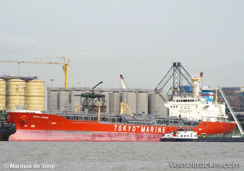
Ginga Saker
Current StatusWhere is the vessel?
Ginga Saker is currently in Near Map Ta Phut, based on AIS data received about 1h ago.
Latest AIS update:
Current position: 12.59393° N, 101.20208° E (Near Map Ta Phut)
Average speed (last 7 days): Loading…
Average speed (last 30 days): Loading…
Vessel profile: Ginga Saker is a Chemical Oil Products Tanker with dimensions 24m x 148m.
This page combines live AIS, route history, probable destination signals, nearby traffic, and port activity for practical vessel monitoring.
The current position of vessel Ginga Saker is 12.59393 lat / 101.20208 lng. Updated: 2026-04-09 19:51:48 UTCNearest reference points:
- 11 nm S of Map Ta Phut
- Near SATTAHIP
- 33 nm S of SATTAHIP
Details:
Live Vessel Ginga Saker Analytics (details, animations, etc.)
Recent AIS points (UTC):
2026-04-09 14:18:48 UTC · 12.59408, 101.20178 · SOG 0 kn · COG 168°2026-04-09 16:15:48 UTC · 12.59433, 101.20170 · SOG 0.1 kn · COG 175°
2026-04-09 17:45:48 UTC · 12.59423, 101.20203 · SOG 0.1 kn · COG 187°
2026-04-09 19:51:48 UTC · 12.59393, 101.20208 · SOG 0.2 kn · COG 181°