 vesseltracker.com
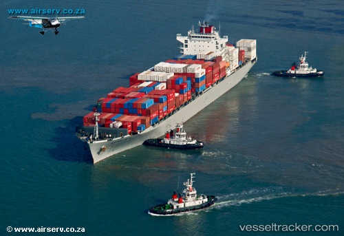
 Alexandria Bridge
Current Status
Where is the vessel?
Alexandria Bridge is currently in 22 nm S of Kenton-on-Sea, based on AIS data received about 1h ago.
Latest AIS update:
Current position: 34.03023° S, 26.57247° E (22 nm S of Kenton-on-Sea)
Average speed (last 7 days): Loading…
Average speed (last 30 days): Loading…
Vessel profile: Alexandria Bridge is a Container Ship with dimensions 262m x 32m.
This page combines live AIS, route history, probable destination signals, nearby traffic, and port activity for practical vessel monitoring.
The current position of vessel Alexandria Bridge is -34.03023 lat / 26.57247 lng. Updated: 2026-04-13 12:11:27 UTCNearest reference points:
- Near Deal Party
- 21 nm S of Mount Pleasant
Currently sailing under the flag of Panama ![]()
Details:
Live Vessel Alexandria Bridge Analytics (details, animations, etc.)
Recent AIS points (UTC):
2026-04-13 06:21:33 UTC · -33.18051, 28.20398 · SOG 17.4 kn · COG 231°2026-04-13 08:04:08 UTC · -33.48700, 27.73990 · SOG 16.8 kn · COG 235°
2026-04-13 09:57:05 UTC · -33.81036, 27.22935 · SOG 16.4 kn · COG 240°
2026-04-13 12:11:27 UTC · -34.03023, 26.57247 · SOG 16 kn · COG 250°