 vesseltracker.com
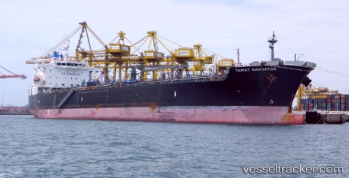
 Tamiat Navigator
Current Status
Where is the vessel?
Tamiat Navigator is currently in Near PURFLEET, based on AIS data received about 1h ago.
Latest AIS update:
Current position: 51.46374° N, 0.26639° E (Near PURFLEET)
Average speed (last 7 days): Loading…
Average speed (last 30 days): Loading…
Vessel profile: Tamiat Navigator is a Chemical Oil Products Tanker with dimensions 183m x 32m.
This page combines live AIS, route history, probable destination signals, nearby traffic, and port activity for practical vessel monitoring.
The current position of vessel Tamiat Navigator is 51.46374 lat / 0.26639 lng. Updated: 2026-04-21 09:37:44 UTCNearest reference points:
- Near Gravesend
- Near Blackheath/London
- Near GILLINGHAM
Currently sailing under the flag of Panama ![]()
Tamiat Navigator built in 2010 year
Deadweight:
46625 tDetails:
Live Vessel Tamiat Navigator Analytics (details, animations, etc.)
Recent AIS points (UTC):
2026-04-21 06:22:50 UTC · 51.46373, 0.26637 · SOG 0 kn · COG 124°2026-04-21 07:55:54 UTC · 51.46371, 0.26637 · SOG 0 kn · COG 124°
2026-04-21 07:55:54 UTC · 51.46371, 0.26637 · SOG 0 kn · COG 124°
2026-04-21 09:37:44 UTC · 51.46374, 0.26639 · SOG 0 kn · COG 124°