 vesseltracker.com
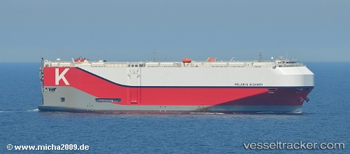
 Polaris Highway
Current Status
Where is the vessel?
Polaris Highway is currently in 142 nm SW of PUERTO MADERO, based on AIS data received less than 1h ago.
Latest AIS update:
Current position: 13.33056° N, 94.39783° W (142 nm SW of PUERTO MADERO)
Average speed (last 7 days): Loading…
Average speed (last 30 days): Loading…
Vessel profile: Polaris Highway is a Vehicles Carrier with dimensions 199m x 38m.
This page combines live AIS, route history, probable destination signals, nearby traffic, and port activity for practical vessel monitoring.
The current position of vessel Polaris Highway is 13.33056 lat / -94.39783 lng. Updated: 2026-03-29 10:17:59 UTCCurrently sailing under the flag of Panama ![]()
Details:
Live Vessel Polaris Highway Analytics (details, animations, etc.)
Recent AIS points (UTC):
2026-03-29 03:39:24 UTC · 14.12908, -95.83885 · SOG 14.2 kn · COG 105°2026-03-29 05:22:45 UTC · 13.94688, -95.45602 · SOG 15 kn · COG 108°
2026-03-29 08:15:46 UTC · 13.51943, -94.90879 · SOG 15.3 kn · COG 105°
2026-03-29 10:17:59 UTC · 13.33056, -94.39783 · SOG 16 kn · COG 100°