 vesseltracker.com
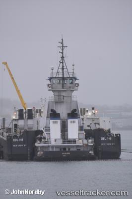
 Lincoln Sea
Current Status
Where is the vessel?
Lincoln Sea is currently in Near Corpus Christi, based on AIS data received less than 1h ago.
Latest AIS update:
Current position: 27.82442° N, 97.43581° W (Near Corpus Christi)
Average speed (last 7 days): Loading…
Average speed (last 30 days): Loading…
Vessel profile: Lincoln Sea is a Pusher Tug with dimensions 181m x 24m.
This page combines live AIS, route history, probable destination signals, nearby traffic, and port activity for practical vessel monitoring.
The current position of vessel Lincoln Sea is 27.82442 lat / -97.43581 lng. Updated: 2026-04-10 07:59:49 UTCNearest reference points:
- Near Corpus Christi
- Near Aransas Pass
- Near ARANSAS PASS
Currently sailing under the flag of USA ![]()
Lincoln Sea built in 2000 year
Deadweight:
749 tDetails:
Live Vessel Lincoln Sea Analytics (details, animations, etc.)
Recent AIS points (UTC):
2026-04-10 02:38:46 UTC · 27.82444, -97.43583 · SOG 0 kn · COG 116°2026-04-10 04:23:55 UTC · 27.82443, -97.43576 · SOG 0 kn · COG 115°
2026-04-10 05:29:51 UTC · 27.82441, -97.43585 · SOG 0 kn · COG 115°
2026-04-10 07:59:49 UTC · 27.82442, -97.43581 · SOG 0 kn · COG 116°