 vesseltracker.com
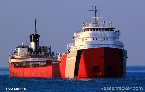
 John G Munson
Current Status
Where is the vessel?
John G Munson is currently in Near De Tour Village, based on AIS data received about 1h ago.
Latest AIS update:
Current position: 46.04511° N, 83.88917° W (Near De Tour Village)
Average speed (last 7 days): Loading…
Average speed (last 30 days): Loading…
Vessel profile: John G Munson is a Self Discharging Bulk Carrier with dimensions 234m x 22m.
This page combines live AIS, route history, probable destination signals, nearby traffic, and port activity for practical vessel monitoring.
The current position of vessel John G Munson is 46.04511 lat / -83.88917 lng. Updated: 2026-04-09 21:23:34 UTCNearest reference points:
- Near Meldrum
- Near Mackinaw City
Currently sailing under the flag of USA ![]()
John G Munson built in 1952 year
Deadweight:
26011 tDetails:
Live Vessel John G Munson Analytics (details, animations, etc.)
Recent AIS points (UTC):
2026-04-09 16:24:04 UTC · 46.04512, -83.88896 · SOG 0.1 kn · COG 283°2026-04-09 18:02:05 UTC · 46.04486, -83.88960 · SOG 0.1 kn · COG 290°
2026-04-09 20:00:25 UTC · 46.04548, -83.88912 · SOG 0.1 kn · COG 260°
2026-04-09 21:23:34 UTC · 46.04511, -83.88917 · SOG 0.6 kn · COG 302°