 vesseltracker.com
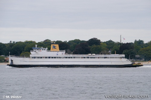
 Cape Henlopen
Current Status
Where is the vessel?
Cape Henlopen is currently in Near PLUM ISLAND, based on AIS data received about 3h ago.
Latest AIS update:
Current position: 41.15409° N, 72.24008° W (Near PLUM ISLAND)
Average speed (last 7 days): Loading…
Average speed (last 30 days): Loading…
Vessel profile: Cape Henlopen is a Passenger Ro Ro Cargo Ship with dimensions 94m x 15m.
This page combines live AIS, route history, probable destination signals, nearby traffic, and port activity for practical vessel monitoring.
The current position of vessel Cape Henlopen is 41.15409 lat / -72.24008 lng. Updated: 2026-04-08 23:45:13 UTCNearest reference points:
- Near PLUM ISLAND
- Near Springville, Suffolk
- Near JUDITH POINT
Currently sailing under the flag of USA ![]()
Details:
Live Vessel Cape Henlopen Analytics (details, animations, etc.)
Recent AIS points (UTC):
2026-04-08 19:42:34 UTC · 41.15407, -72.24008 · SOG 0 kn · COG 312°2026-04-08 21:28:44 UTC · 41.35536, -72.09156 · SOG 0.2 kn · COG 113°
2026-04-08 23:45:13 UTC · 41.15409, -72.24008 · SOG 0 kn · COG 312°
2026-04-08 23:45:13 UTC · 41.15409, -72.24008 · SOG 0 kn · COG 312°