 vesseltracker.com
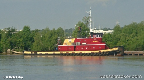
 Dee White
Current Status
Where is the vessel?
Dee White is currently in Near Myrtle Grove, based on AIS data received about 1h ago.
Latest AIS update:
Current position: 29.61833° N, 89.90833° W (Near Myrtle Grove)
Average speed (last 7 days): Loading…
Average speed (last 30 days): Loading…
Vessel profile: Dee White is a Tug with dimensions 35m x 11m.
This page combines live AIS, route history, probable destination signals, nearby traffic, and port activity for practical vessel monitoring.
The current position of vessel Dee White is 29.61833 lat / -89.90833 lng. Updated: 2026-04-14 12:03:34 UTCNearest reference points:
- Near Pointe a la Hache
- Near Port Sulphur
- Near Meraux
Currently sailing under the flag of USA ![]()
Dee White built in 1995 year
Deadweight:
430 tDetails:
Live Vessel Dee White Analytics (details, animations, etc.)
Recent AIS points (UTC):
2026-04-14 06:08:09 UTC · 29.61927, -89.90967 · SOG 0 kn · COG 295°2026-04-14 08:13:54 UTC · 29.61927, -89.90967 · SOG 0.1 kn · COG 293°
2026-04-14 09:24:32 UTC · 29.61833, -89.90833 · SOG 0 kn · COG -1°
2026-04-14 12:03:34 UTC · 29.61833, -89.90833 · SOG 0 kn · COG -1°