 vesseltracker.com
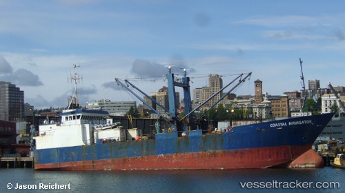
Coastal Navigator
Current StatusWhere is the vessel?
Coastal Navigator is currently in Near Ballard/Seattle, based on AIS data received about 6d ago.
Latest AIS update:
Current position: 47.65717° N, 122.37474° W (Near Ballard/Seattle)
Average speed (last 7 days): Loading…
Average speed (last 30 days): Loading…
Vessel profile: Coastal Navigator is a Refrigerated Cargo Ship with dimensions 12m x 72m.
This page combines live AIS, route history, probable destination signals, nearby traffic, and port activity for practical vessel monitoring.
The current position of vessel Coastal Navigator is 47.65717 lat / -122.37474 lng. Updated: 2026-04-15 05:23:13 UTCNearest reference points:
- Near Ballard/Seattle
- Near Interbay
- Near SHILSHOLE
Details:
Live Vessel Coastal Navigator Analytics (details, animations, etc.)
Recent AIS points (UTC):
2026-04-15 04:05:02 UTC · 47.65718, -122.37472 · SOG 0 kn · COG 91°2026-04-15 05:23:13 UTC · 47.65717, -122.37474 · SOG 0 kn · COG 91°
2026-04-15 05:23:13 UTC · 47.65717, -122.37474 · SOG 0 kn · COG 91°
2026-04-15 05:23:13 UTC · 47.65717, -122.37474 · SOG 0 kn · COG 91°