 vesseltracker.com
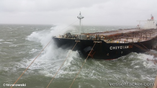
 Chiyotamou
Current Status
Where is the vessel?
Chiyotamou is currently in Open sea (no nearby ports in database), based on AIS data received about 2h ago.
Latest AIS update:
Current position: 6.74833° S, 4.52167° W (Open sea (no nearby ports in database))
Average speed (last 7 days): Loading…
Average speed (last 30 days): Loading…
Vessel profile: Chiyotamou is a Ore Carrier with dimensions 320m x 320m.
This page combines live AIS, route history, probable destination signals, nearby traffic, and port activity for practical vessel monitoring.
The current position of vessel Chiyotamou is -6.74833 lat / -4.52167 lng. Updated: 2026-04-16 13:26:13 UTCNearest reference points:
- Open sea (no nearby ports in database)
- Open sea, approx. 482 nm off the nearest listed port
- Open sea, approx. 480 nm off the nearest listed port
Currently sailing under the flag of Panama ![]()
Chiyotamou built in 2008 year
Deadweight:
228627 tDetails:
Live Vessel Chiyotamou Analytics (details, animations, etc.)
Recent AIS points (UTC):
2026-04-16 08:23:44 UTC · -6.01319, -5.01384 · SOG 10.4 kn · COG 141°2026-04-16 09:50:13 UTC · -6.22667, -4.87333 · SOG 10 kn · COG -1°
2026-04-16 11:53:14 UTC · -6.52500, -4.66667 · SOG 10 kn · COG -1°
2026-04-16 13:26:13 UTC · -6.74833, -4.52167 · SOG 10 kn · COG -1°