 vesseltracker.com
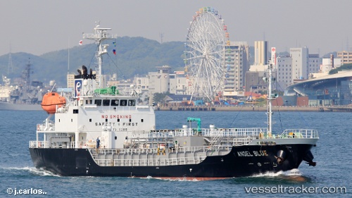
 Angel Blue
Current Status
Where is the vessel?
Angel Blue is currently in Near Hibikishinko, based on AIS data received about 1d ago.
Latest AIS update:
Current position: 34.12571° N, 130.73244° E (Near Hibikishinko)
Average speed (last 7 days): Loading…
Average speed (last 30 days): Loading…
Vessel profile: Angel Blue is a Bitumen Tanker with dimensions 74m x 12m.
This page combines live AIS, route history, probable destination signals, nearby traffic, and port activity for practical vessel monitoring.
The current position of vessel Angel Blue is 34.12571 lat / 130.73244 lng. Updated: 2026-04-10 06:17:08 UTCNearest reference points:
- Near Hibikishinko
- Near KITAKYUSHU
- Near Kokura
Currently sailing under the flag of Panama ![]()
Details:
Live Vessel Angel Blue Analytics (details, animations, etc.)
Recent AIS points (UTC):
2026-04-10 01:52:38 UTC · 33.83044, 131.42747 · SOG 12 kn · COG 281°2026-04-10 03:55:28 UTC · 33.98104, 130.99898 · SOG 10.5 kn · COG 265°
2026-04-10 05:44:30 UTC · 34.05911, 130.80934 · SOG 10.6 kn · COG 310°
2026-04-10 06:17:08 UTC · 34.12571, 130.73244 · SOG 9.5 kn · COG 310°