 vesseltracker.com
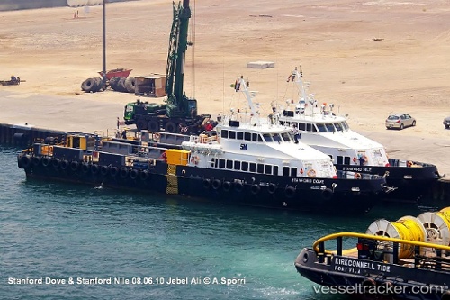
 Stanford Dove
Current Status
Where is the vessel?
Stanford Dove is currently in Near DUBAI, based on AIS data received about 2h ago.
Latest AIS update:
Current position: 25.27272° N, 55.26144° E (Near DUBAI)
Average speed (last 7 days): Loading…
Average speed (last 30 days): Loading…
Vessel profile: Stanford Dove is a Offshore Tug Supply Ship with dimensions 41m x 41m.
This page combines live AIS, route history, probable destination signals, nearby traffic, and port activity for practical vessel monitoring.
The current position of vessel Stanford Dove is 25.27272 lat / 55.26144 lng. Updated: 2026-04-22 13:41:52 UTCNearest reference points:
- Near DUBAI
- Near Free Port
- Near Dubai
Currently sailing under the flag of St Vincent Grenadines ![]()
Details:
Live Vessel Stanford Dove Analytics (details, animations, etc.)
Recent AIS points (UTC):
2026-04-22 10:24:00 UTC · 25.27270, 55.26142 · SOG 0.1 kn · COG -1°2026-04-22 11:20:53 UTC · 25.27274, 55.26143 · SOG 0.1 kn · COG -1°
2026-04-22 13:14:52 UTC · 25.27267, 55.26146 · SOG 0.1 kn · COG -1°
2026-04-22 13:41:52 UTC · 25.27272, 55.26144 · SOG 0.1 kn · COG -1°