 vesseltracker.com
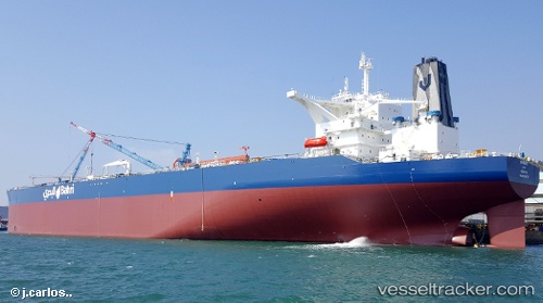
 KHURAIS
Current Status
Where is the vessel?
KHURAIS is currently in Near Yokkaichi, based on AIS data received less than 1h ago.
Latest AIS update:
Current position: 34.92845° N, 136.70097° E (Near Yokkaichi)
Average speed (last 7 days): Loading…
Average speed (last 30 days): Loading…
Vessel profile: KHURAIS is a Tanker with dimensions m x m.
This page combines live AIS, route history, probable destination signals, nearby traffic, and port activity for practical vessel monitoring.
The current position of vessel KHURAIS is 34.92845 lat / 136.70097 lng. Updated: 2026-04-18 03:47:06 UTCNearest reference points:
- Near Yokkaichi
- Near Nagoya
- Near Kinuura
Currently sailing under the flag of Saudi Arabia ![]()
Details:
Live Vessel KHURAIS Analytics (details, animations, etc.)
Recent AIS points (UTC):
2026-04-17 21:44:20 UTC · 34.92793, 136.73962 · SOG 0 kn · COG 180°2026-04-17 23:51:59 UTC · 34.92792, 136.73962 · SOG 0 kn · COG 180°
2026-04-18 01:36:43 UTC · 34.91679, 136.72983 · SOG 3.7 kn · COG 244°
2026-04-18 03:47:06 UTC · 34.92845, 136.70097 · SOG 0.1 kn · COG 29°