 vesseltracker.com
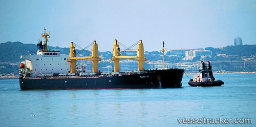
 KANG YU
Current Status
Where is the vessel?
KANG YU is currently in 12 nm S of Hon La Port, based on AIS data received less than 1h ago.
Latest AIS update:
Current position: 17.72667° N, 106.52500° E (12 nm S of Hon La Port)
Average speed (last 7 days): Loading…
Average speed (last 30 days): Loading…
Vessel profile: KANG YU is a Bulk Carrier with dimensions 189m x 32m.
This page combines live AIS, route history, probable destination signals, nearby traffic, and port activity for practical vessel monitoring.
The current position of vessel KANG YU is 17.72667 lat / 106.52500 lng. Updated: 2026-03-30 08:20:39 UTCNearest reference points:
- 61 nm E of Hon La Port
- 48 nm NE of Cua Viet Port
- 60 nm NE of Son Duong Port
Currently sailing under the flag of China Peopless Republic ![]()
KANG YU built in 2004 year
Deadweight:
52988 tDetails:
Live Vessel KANG YU Analytics (details, animations, etc.)
Recent AIS points (UTC):
2026-03-30 01:30:21 UTC · 17.72500, 106.52500 · SOG 0 kn · COG -1°2026-03-30 03:54:02 UTC · 17.72599, 106.52500 · SOG 0 kn · COG 68°
2026-03-30 05:53:04 UTC · 17.72654, 106.52487 · SOG 0 kn · COG 86°
2026-03-30 08:20:39 UTC · 17.72667, 106.52500 · SOG 0 kn · COG -1°