 vesseltracker.com
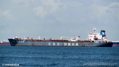
Chang Hang Hong Tu
Current StatusWhere is the vessel?
Chang Hang Hong Tu is currently in 186 nm NE of LIZARD ISLAND, based on AIS data received about 1d ago.
Latest AIS update:
Current position: 13.15650° S, 148.23088° E (186 nm NE of LIZARD ISLAND)
Average speed (last 7 days): Loading…
Average speed (last 30 days): Loading…
Vessel profile: Chang Hang Hong Tu is a Oil Products Tanker with dimensions 33m x 185m.
This page combines live AIS, route history, probable destination signals, nearby traffic, and port activity for practical vessel monitoring.
The current position of vessel Chang Hang Hong Tu is -13.15650 lat / 148.23088 lng. Updated: 2026-04-10 07:12:42 UTCNearest reference points:
- 209 nm N of Coral Sea
Details:
Live Vessel Chang Hang Hong Tu Analytics (details, animations, etc.)
Recent AIS points (UTC):
2026-04-10 02:35:01 UTC · -12.59985, 147.64240 · SOG 10 kn · COG 132°2026-04-10 03:29:37 UTC · -12.70667, 147.75667 · SOG 10 kn · COG -1°
2026-04-10 06:02:37 UTC · -13.00667, 148.07333 · SOG 10 kn · COG -1°
2026-04-10 07:12:42 UTC · -13.15650, 148.23088 · SOG 10.6 kn · COG 134°