 vesseltracker.com
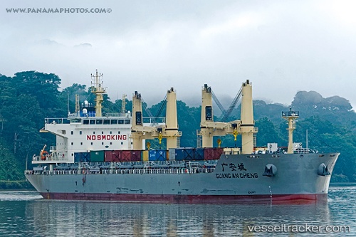
 GUANG AN CHENG
Current Status
Where is the vessel?
GUANG AN CHENG is currently in 388 nm NW of Amurang, based on AIS data received about 2h ago.
Latest AIS update:
Current position: 6.85238° N, 127.63032° W (388 nm NW of Amurang)
Average speed (last 7 days): Loading…
Average speed (last 30 days): Loading…
Vessel profile: GUANG AN CHENG is a Cargo D with dimensions m x m.
This page combines live AIS, route history, probable destination signals, nearby traffic, and port activity for practical vessel monitoring.
The current position of vessel GUANG AN CHENG is 6.85238 lat / -127.63032 lng. Updated: 2026-03-31 01:31:31 UTCNearest reference points:
- Open sea, approx. 404 nm off the nearest listed port
- Open sea (no nearby ports in database)
- Open sea, approx. 431 nm off the nearest listed port
Currently sailing under the flag of China ![]()
Details:
Live Vessel GUANG AN CHENG Analytics (details, animations, etc.)
Recent AIS points (UTC):
2026-03-30 19:36:42 UTC · 6.86877, -128.82597 · SOG 11.8 kn · COG 90°2026-03-30 22:13:41 UTC · 6.86110, -128.30273 · SOG 12 kn · COG 90°
2026-03-30 23:37:30 UTC · 6.85824, -128.01849 · SOG 12.2 kn · COG 90°
2026-03-31 01:31:31 UTC · 6.85238, -127.63032 · SOG 12.2 kn · COG 90°