 vesseltracker.com
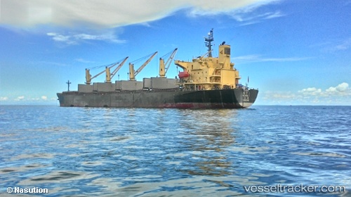
 Rui Ning 1
Current Status
Where is the vessel?
Rui Ning 1 is currently in Near Taku Bar, based on AIS data received about 2h ago.
Latest AIS update:
Current position: 38.97368° N, 118.14058° E (Near Taku Bar)
Average speed (last 7 days): Loading…
Average speed (last 30 days): Loading…
Vessel profile: Rui Ning 1 is a Bulk Carrier with dimensions 190m x 32m.
This page combines live AIS, route history, probable destination signals, nearby traffic, and port activity for practical vessel monitoring.
The current position of vessel Rui Ning 1 is 38.97368 lat / 118.14058 lng. Updated: 2026-03-28 20:10:43 UTCNearest reference points:
- Near Dagu Bar
- Near Taku Bar
- 15 nm N of Taku Bar
Currently sailing under the flag of China ![]()
Rui Ning 1 built in 2001 year
Deadweight:
52394 tDetails:
Live Vessel Rui Ning 1 Analytics (details, animations, etc.)
Recent AIS points (UTC):
2026-03-28 13:54:08 UTC · 38.97404, 118.13708 · SOG 2.5 kn · COG 104°2026-03-28 15:55:44 UTC · 38.97664, 118.13883 · SOG 0 kn · COG 169°
2026-03-28 17:55:43 UTC · 38.97588, 118.14099 · SOG 0 kn · COG 243°
2026-03-28 20:10:43 UTC · 38.97368, 118.14058 · SOG 0 kn · COG 327°