 vesseltracker.com
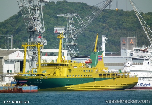
 Tachibana Maru
Current Status
Where is the vessel?
Tachibana Maru is currently in 86 nm S of Toshima/Tokyo, based on AIS data received about 1h ago.
Latest AIS update:
Current position: 33.16130° N, 139.83054° E (86 nm S of Toshima/Tokyo)
Average speed (last 7 days): Loading…
Average speed (last 30 days): Loading…
Vessel profile: Tachibana Maru is a Passenger General Cargo Ship with dimensions 118m x 17m.
This page combines live AIS, route history, probable destination signals, nearby traffic, and port activity for practical vessel monitoring.
The current position of vessel Tachibana Maru is 33.16130 lat / 139.83054 lng. Updated: 2026-04-06 23:29:19 UTCNearest reference points:
- Near Toshima/Tokyo
- Near Nishitokyo
- 10 nm SE of Iruma
Currently sailing under the flag of Japan ![]()
Tachibana Maru built in 2014 year
Deadweight:
1200 tDetails:
Live Vessel Tachibana Maru Analytics (details, animations, etc.)
Recent AIS points (UTC):
2026-04-06 17:18:08 UTC · 34.72817, 139.62144 · SOG 16.5 kn · COG 195°2026-04-06 18:38:54 UTC · 34.34571, 139.51057 · SOG 17.1 kn · COG 196°
2026-04-06 22:01:00 UTC · 33.60397, 139.68060 · SOG 18.5 kn · COG 165°
2026-04-06 23:29:19 UTC · 33.16130, 139.83054 · SOG 18.1 kn · COG 176°