 vesseltracker.com
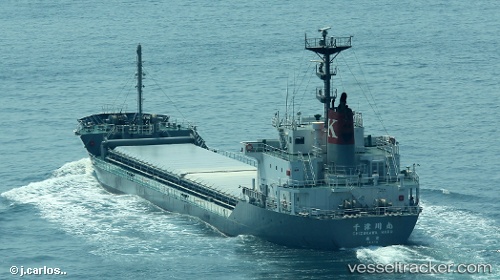
 Chizukawa Maru
Current Status
Where is the vessel?
Chizukawa Maru is currently in Near ANEGASAKI, based on AIS data received about 1d ago.
Latest AIS update:
Current position: 35.55919° N, 139.98878° E (Near ANEGASAKI)
Average speed (last 7 days): Loading…
Average speed (last 30 days): Loading…
Vessel profile: Chizukawa Maru is a Limestone Carrier with dimensions 106m x 17m.
This page combines live AIS, route history, probable destination signals, nearby traffic, and port activity for practical vessel monitoring.
The current position of vessel Chizukawa Maru is 35.55919 lat / 139.98878 lng. Updated: 2026-04-10 08:21:37 UTCNearest reference points:
- Near ANEGASAKI
- Near Aomi
- Near Kawasaki
Currently sailing under the flag of Japan ![]()
Details:
Live Vessel Chizukawa Maru Analytics (details, animations, etc.)
Recent AIS points (UTC):
2026-04-10 01:52:15 UTC · 34.74001, 139.22540 · SOG 12.8 kn · COG 50°2026-04-10 03:55:32 UTC · 35.01662, 139.66486 · SOG 12.7 kn · COG 49°
2026-04-10 05:45:21 UTC · 35.34813, 139.74776 · SOG 12.5 kn · COG 19°
2026-04-10 08:21:37 UTC · 35.55919, 139.98878 · SOG 0 kn · COG 212°