 vesseltracker.com
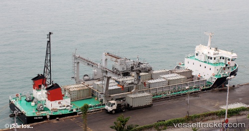
 MO SING LENG
Current Status
Where is the vessel?
MO SING LENG is currently in 50 nm SW of Calatagan, based on AIS data received about 1d ago.
Latest AIS update:
Current position: 13.32441° N, 119.96030° E (50 nm SW of Calatagan)
Average speed (last 7 days): Loading…
Average speed (last 30 days): Loading…
Vessel profile: MO SING LENG is a Container Ship with dimensions m x m.
This page combines live AIS, route history, probable destination signals, nearby traffic, and port activity for practical vessel monitoring.
The current position of vessel MO SING LENG is 13.32441 lat / 119.96030 lng. Updated: 2026-04-18 00:47:25 UTCNearest reference points:
- 19 nm SW of MARIVELES
- Near Nasugbu, Luzon
- Near Lobo
Currently sailing under the flag of Hong Kong ![]()
Details:
Live Vessel MO SING LENG Analytics (details, animations, etc.)
Recent AIS points (UTC):
2026-04-17 14:09:05 UTC · 13.98670, 120.50720 · SOG 5.8 kn · COG 188°2026-04-18 00:47:25 UTC · 13.32441, 119.96030 · SOG 5.3 kn · COG -1°
2026-04-18 00:47:25 UTC · 13.32441, 119.96030 · SOG 5.3 kn · COG -1°
2026-04-18 00:47:25 UTC · 13.32441, 119.96030 · SOG 5.3 kn · COG -1°