 vesseltracker.com
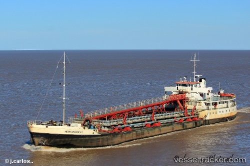
 Hernandarias
Current Status
Where is the vessel?
Hernandarias is currently in Near Dock Sur, based on AIS data received about 1h ago.
Latest AIS update:
Current position: 34.65768° S, 58.33965° W (Near Dock Sur)
Average speed (last 7 days): Loading…
Average speed (last 30 days): Loading…
Vessel profile: Hernandarias is a Oil Products Tanker with dimensions 90m x 15m.
This page combines live AIS, route history, probable destination signals, nearby traffic, and port activity for practical vessel monitoring.
The current position of vessel Hernandarias is -34.65768 lat / -58.33965 lng. Updated: 2026-03-30 02:02:52 UTCNearest reference points:
- Near Dock Sur
- Near Avellaneda
- Near JUAN LACAZE
Currently sailing under the flag of Argentina ![]()
Details:
Live Vessel Hernandarias Analytics (details, animations, etc.)
Recent AIS points (UTC):
2026-03-29 19:32:32 UTC · -34.24033, -58.63523 · SOG 4.5 kn · COG -1°2026-03-29 21:27:11 UTC · -34.38667, -58.45231 · SOG 8.4 kn · COG 153°
2026-03-29 23:34:10 UTC · -34.60952, -58.29104 · SOG 7.5 kn · COG -1°
2026-03-30 02:02:52 UTC · -34.65768, -58.33965 · SOG 0 kn · COG -1°