 vesseltracker.com
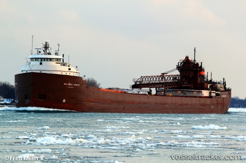
 Hon James L Oberstar
Current Status
Where is the vessel?
Hon James L Oberstar is currently in Near INDIANA HARBOR, based on AIS data received less than 1h ago.
Latest AIS update:
Current position: 41.67542° N, 87.43782° W (Near INDIANA HARBOR)
Average speed (last 7 days): Loading…
Average speed (last 30 days): Loading…
Vessel profile: Hon James L Oberstar is a Self Discharging Bulk Carrier with dimensions 246m x 24m.
This page combines live AIS, route history, probable destination signals, nearby traffic, and port activity for practical vessel monitoring.
The current position of vessel Hon James L Oberstar is 41.67542 lat / -87.43782 lng. Updated: 2026-04-22 10:39:29 UTCNearest reference points:
- Near Burnham
- Near Burns Harbor
- Near WAUKEGAN
Currently sailing under the flag of USA ![]()
Hon James L Oberstar built in 1959 year
Deadweight:
32412 tDetails:
Live Vessel Hon James L Oberstar Analytics (details, animations, etc.)
Recent AIS points (UTC):
2026-04-22 07:42:28 UTC · 41.67545, -87.43783 · SOG 0 kn · COG 344°2026-04-22 08:12:31 UTC · 41.67545, -87.43779 · SOG 0 kn · COG 344°
2026-04-22 09:33:32 UTC · 41.67544, -87.43781 · SOG 0 kn · COG 344°
2026-04-22 10:39:29 UTC · 41.67542, -87.43782 · SOG 0 kn · COG 344°