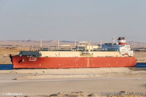
.
Vessel photo of Al Thumama (IMO 9360843) vesseltracker.com

Al Thumama

Vessel type: Lng Tanker | IMO: 9360843 | MMSI: MMSI: 538003018
Call sign: V7NU3 | Dimensions: 49 m x 315 m
Current Status

Where is the vessel?

Al Thumama is currently in 26 nm SE of Pulau Jarak, based on AIS data received about 1h ago.

Latest AIS update:

Current position: 3.57765° N, 100.29088° E (26 nm SE of Pulau Jarak)

Average speed (last 7 days): Loading…

Average speed (last 30 days): Loading…

Vessel profile: Al Thumama is a Lng Tanker with dimensions 49m x 315m.

This page combines live AIS, route history, probable destination signals, nearby traffic, and port activity for practical vessel monitoring.

The current position of vessel Al Thumama is 3.57765 lat / 100.29088 lng. Updated: 2026-04-19 16:19:05 UTC
Nearest reference points:
  • 11 nm W of Pangkur
  • Near PANGKOR
  • Near Simpang Lima
Details:

Live Vessel Al Thumama Analytics (details, animations, etc.)


Recent AIS points (UTC):
2026-04-19 13:35:48 UTC · 3.02646, 100.81669 · SOG 16.3 kn · COG 318°
2026-04-19 14:03:33 UTC · 3.11667, 100.72667 · SOG 17 kn · COG -1°
2026-04-19 16:04:11 UTC · 3.53107, 100.34267 · SOG 16.9 kn · COG 311°
2026-04-19 16:19:05 UTC · 3.57765, 100.29088 · SOG 16.8 kn · COG 311°

Track of the vessel in the last 60 days


UTC: --
Start: -- Track timeline (UTC) End: --
Encountered: --


Link to the map:


Find another ship

Al_Thumama (538003018) last ports (portcalls and passsages)

RAS LAFFAN | 2025-08-23 22:32:33
AL KHIRAN | 2025-08-20 04:25:39
RAS LAFFAN | 2025-08-15 22:05:12
BUKOM ISLAND | 2025-08-02 00:16:45
JURONG ISLAND | 2025-08-01 03:33:09
RAS LAFFAN | 2025-07-20 02:04:17
JURONG ISLAND | 2025-07-09 08:20:29
BUKOM ISLAND | 2025-07-08 06:23:02
TANAH MERAH | 2025-07-08 05:14:53
PENGERANG | 2025-07-08 04:11:09
PENGERANG | 2025-06-17 09:45:03
TANAH MERAH | 2025-06-17 08:41:04
BATU AMPAR | 2025-06-17 08:23:21
RAS LAFFAN | 2025-06-05 12:52:28
Durban | 2025-05-14 12:12:22
Strait Of Gibraltar | 2025-04-25 18:09:24
TARIFA | 2025-04-25 17:25:43
CARTEYA GUADARRANQUE | 2025-04-24 06:59:59
Strait Of Gibraltar | 2025-04-06 17:28:57
RAS LAFFAN | 2025-03-07 20:32:29
TARIFA | 2025-02-07 10:25:07
CARTEYA GUADARRANQUE | 2025-02-06 14:21:31
Strait Of Gibraltar | 2025-01-21 13:35:18
RAS LAFFAN | 2024-12-24 20:24:25
Strait Of Gibraltar | 2024-11-24 12:35:52
CARTEYA GUADARRANQUE | 2024-11-23 15:09:11
TARIFA | 2024-11-08 17:22:28
Skagens Odde | 2024-09-07 10:53:01
Korsor | 2024-09-06 06:19:48
Swinoujscie | 2024-09-04 06:45:58
Algeciras | 2024-06-21 17:01:52
St. Louis Du Rhone | 2024-06-17 14:53:14
Strait Of Gibraltar | 2024-06-10 08:17:11
Strait Of Gibraltar | 2024-04-12 06:27:06
Algeciras | 2024-04-10 22:02:54
Ceuta | 2024-03-23 04:17:20
Singapore | 2024-02-10 05:15:04
Map Ta Phut | 2024-02-06 05:59:55
Sambu | 2024-02-04 02:25:35
Singapore | 2024-01-12 02:30:48
Singapore | 2023-12-27 04:02:01
Singapore | 2023-10-30 03:12:13
Sambu | 2023-10-30 02:19:29
Map Ta Phut | 2023-10-26 23:08:23
Sambu | 2023-10-22 05:12:43
Mina Saud | 2023-10-07 04:39:11
Ra’S Shukhayr | 2023-09-18 21:20:43
Bur Ibrahim | 2023-09-18 13:19:38
Port Said | 2023-09-18 03:08:45
Port Said | 2023-09-06 17:05:24
Bur Ibrahim | 2023-09-06 06:44:03
Ras Gharib | 2023-08-16 00:21:21
Bur Ibrahim | 2023-08-15 14:23:18
Port Said | 2023-08-15 05:02:28
Bur Ibrahim | 2023-07-30 04:46:28
Port Said | 2023-06-21 20:18:09
Bur Ibrahim | 2023-06-21 10:57:25
Singapore | 2023-05-22 07:26:15
Sambu | 2023-05-09 04:59:50
Singapore | 2023-04-15 12:32:45
Sambu | 2023-04-15 12:16:17
Bur Ibrahim | 2023-01-31 05:40:06
Singapore | 2023-01-10 08:33:03
Yokosuka | 2022-12-06 02:49:19
Port Said | 2022-07-22 04:35:00
Port Said | 2022-07-13 16:07:55
Bur Ibrahim | 2022-07-13 07:30:53
Sambu | 2022-02-23 21:15:48