 vesseltracker.com
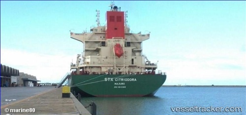
 Citriodora
Current Status
Where is the vessel?
Citriodora is currently in Near St. John, based on AIS data received less than 1h ago.
Latest AIS update:
Current position: 45.26692° N, 66.06818° W (Near St. John)
Average speed (last 7 days): Loading…
Average speed (last 30 days): Loading…
Vessel profile: Citriodora is a General Cargo Ship with dimensions 200m x 32m.
This page combines live AIS, route history, probable destination signals, nearby traffic, and port activity for practical vessel monitoring.
The current position of vessel Citriodora is 45.26692 lat / -66.06818 lng. Updated: 2026-04-21 05:08:01 UTCNearest reference points:
- Near St. John
- Near Tiverton
- 16 nm W of Tiverton
Currently sailing under the flag of Marshall Is ![]()
Citriodora built in 2013 year
Deadweight:
57440 tDetails:
Live Vessel Citriodora Analytics (details, animations, etc.)
Recent AIS points (UTC):
2026-04-21 01:29:01 UTC · 45.26687, -66.06817 · SOG 0 kn · COG 311°2026-04-21 01:32:15 UTC · 45.26688, -66.06815 · SOG 0 kn · COG 311°
2026-04-21 03:59:38 UTC · 45.26687, -66.06817 · SOG 0 kn · COG 311°
2026-04-21 05:08:01 UTC · 45.26692, -66.06818 · SOG 0 kn · COG 311°