 vesseltracker.com
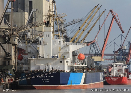
Ionic Storm
Current StatusWhere is the vessel?
Ionic Storm is currently in Near Humewood, based on AIS data received less than 1h ago.
Latest AIS update:
Current position: 33.96170° S, 25.63365° E (Near Humewood)
Average speed (last 7 days): Loading…
Average speed (last 30 days): Loading…
Vessel profile: Ionic Storm is a Bulk Carrier with dimensions 32m x 187m.
This page combines live AIS, route history, probable destination signals, nearby traffic, and port activity for practical vessel monitoring.
The current position of vessel Ionic Storm is -33.96170 lat / 25.63365 lng. Updated: 2026-04-18 09:36:14 UTCNearest reference points:
- Near Deal Party
- 21 nm S of Mount Pleasant
Details:
Live Vessel Ionic Storm Analytics (details, animations, etc.)
Recent AIS points (UTC):
2026-04-18 03:58:43 UTC · -33.96167, 25.63333 · SOG 0 kn · COG -1°2026-04-18 06:12:14 UTC · -33.96175, 25.63365 · SOG 0 kn · COG 261°
2026-04-18 08:03:20 UTC · -33.96174, 25.63365 · SOG 0 kn · COG 261°
2026-04-18 09:36:14 UTC · -33.96170, 25.63365 · SOG 0 kn · COG 261°