 vesseltracker.com
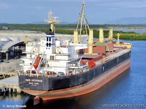
 San Antonio
Current Status
Where is the vessel?
San Antonio is currently in Near Apapa, based on AIS data received about 1h ago.
Latest AIS update:
Current position: 6.30348° N, 3.38790° E (Near Apapa)
Average speed (last 7 days): Loading…
Average speed (last 30 days): Loading…
Vessel profile: San Antonio is a Bulk Carrier with dimensions 190m x 190m.
This page combines live AIS, route history, probable destination signals, nearby traffic, and port activity for practical vessel monitoring.
The current position of vessel San Antonio is 6.30348 lat / 3.38790 lng. Updated: 2026-04-22 22:01:18 UTCNearest reference points:
- Near Apapa
- Near Lagos
- Near Kirikiri
Currently sailing under the flag of Marshall Is ![]()
San Antonio built in 2012 year
Deadweight:
55768 tDetails:
Live Vessel San Antonio Analytics (details, animations, etc.)
Recent AIS points (UTC):
2026-04-22 19:31:18 UTC · 6.30347, 3.38797 · SOG 0.1 kn · COG 223°2026-04-22 20:04:17 UTC · 6.30360, 3.38777 · SOG 0.1 kn · COG 210°
2026-04-22 21:43:20 UTC · 6.30347, 3.38800 · SOG 0.2 kn · COG 210°
2026-04-22 22:01:18 UTC · 6.30348, 3.38790 · SOG 0.2 kn · COG 205°