 vesseltracker.com
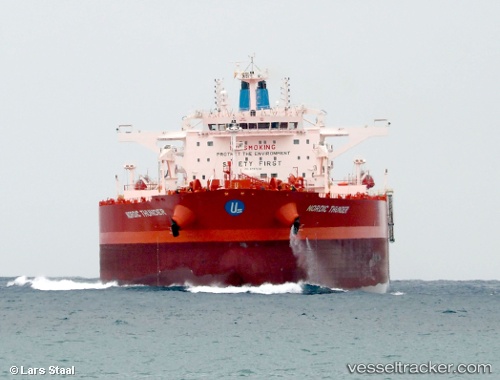
 Nordic Thunder
Current Status
Where is the vessel?
Nordic Thunder is currently in 42 nm N of Matanzas, based on AIS data received about 7h ago.
Latest AIS update:
Current position: 23.73626° N, 81.73202° W (42 nm N of Matanzas)
Average speed (last 7 days): Loading…
Average speed (last 30 days): Loading…
Vessel profile: Nordic Thunder is a Crude Oil Tanker with dimensions 277m x 48m.
This page combines live AIS, route history, probable destination signals, nearby traffic, and port activity for practical vessel monitoring.
The current position of vessel Nordic Thunder is 23.73626 lat / -81.73202 lng. Updated: 2026-04-12 19:59:08 UTCNearest reference points:
- Near Summerland Key
- Near Key West
- 28 nm NE of VARADERO
Currently sailing under the flag of Marshall Is ![]()
Details:
Live Vessel Nordic Thunder Analytics (details, animations, etc.)
Recent AIS points (UTC):
2026-04-12 19:28:53 UTC · 23.74200, -81.62973 · SOG 11 kn · COG -1°2026-04-12 19:59:08 UTC · 23.73626, -81.73202 · SOG 11.1 kn · COG 269°
2026-04-12 19:59:08 UTC · 23.73626, -81.73202 · SOG 11.1 kn · COG 269°
2026-04-12 19:59:08 UTC · 23.73626, -81.73202 · SOG 11.1 kn · COG 269°