 vesseltracker.com
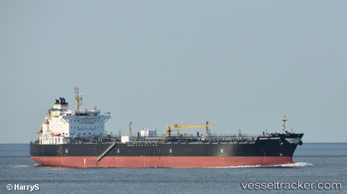
Largo Mariner
Current StatusWhere is the vessel?
Largo Mariner is currently in 17 nm SE of Sheppard, based on AIS data received about 1d ago.
Latest AIS update:
Current position: 29.09266° N, 94.57823° W (17 nm SE of Sheppard)
Average speed (last 7 days): Loading…
Average speed (last 30 days): Loading…
Vessel profile: Largo Mariner is a Chemical Oil Products Tanker with dimensions 32m x 183m.
This page combines live AIS, route history, probable destination signals, nearby traffic, and port activity for practical vessel monitoring.
The current position of vessel Largo Mariner is 29.09266 lat / -94.57823 lng. Updated: 2026-04-10 07:51:23 UTCNearest reference points:
- 12 nm SE of Port Bolivar
- Near Port Bolivar
- 39 nm S of Sheppard
Details:
Live Vessel Largo Mariner Analytics (details, animations, etc.)
Recent AIS points (UTC):
2026-04-10 02:40:18 UTC · 29.09269, -94.57819 · SOG 0 kn · COG 100°2026-04-10 04:23:54 UTC · 29.09263, -94.57819 · SOG 0 kn · COG 97°
2026-04-10 04:54:06 UTC · 29.09267, -94.57820 · SOG 0 kn · COG -1°
2026-04-10 07:51:23 UTC · 29.09266, -94.57823 · SOG 0 kn · COG 95°