 vesseltracker.com
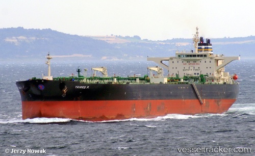
 Yannis P
Current Status
Where is the vessel?
Yannis P is currently in 13 nm N of Port Said, based on AIS data received about 2h ago.
Latest AIS update:
Current position: 31.47425° N, 32.27797° E (13 nm N of Port Said)
Average speed (last 7 days): Loading…
Average speed (last 30 days): Loading…
Vessel profile: Yannis P is a Crude Oil Tanker with dimensions 274m x 48m.
This page combines live AIS, route history, probable destination signals, nearby traffic, and port activity for practical vessel monitoring.
The current position of vessel Yannis P is 31.47425 lat / 32.27797 lng. Updated: 2026-03-29 01:05:46 UTCNearest reference points:
- 15 nm N of Port Said
- 14 nm N of Port Said
- 16 nm N of Port Said
Currently sailing under the flag of Marshall Is ![]()
Yannis P built in 2010 year
Deadweight:
158149 tDetails:
Live Vessel Yannis P Analytics (details, animations, etc.)
Recent AIS points (UTC):
2026-03-28 19:35:12 UTC · 31.47500, 32.27223 · SOG 0.3 kn · COG 100°2026-03-28 21:40:27 UTC · 31.47653, 32.27327 · SOG 0 kn · COG -1°
2026-03-28 23:20:37 UTC · 31.47627, 32.27723 · SOG 0.1 kn · COG -1°
2026-03-29 01:05:46 UTC · 31.47425, 32.27797 · SOG 0 kn · COG -1°