 vesseltracker.com
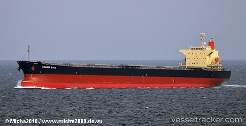
 BLUE IONIAN
Current Status
Where is the vessel?
BLUE IONIAN is currently in 356 nm N of Tinaquillo, based on AIS data received less than 1h ago.
Latest AIS update:
Current position: 15.48865° N, 66.21397° E (356 nm N of Tinaquillo)
Average speed (last 7 days): Loading…
Average speed (last 30 days): Loading…
Vessel profile: BLUE IONIAN is a Bulk Carrier with dimensions 32m x 225m.
This page combines live AIS, route history, probable destination signals, nearby traffic, and port activity for practical vessel monitoring.
The current position of vessel BLUE IONIAN is 15.48865 lat / 66.21397 lng. Updated: 2026-04-20 00:10:48 UTCNearest reference points:
- Open sea, approx. 401 nm off the nearest listed port
- Open sea, approx. 404 nm off the nearest listed port
- Open sea, approx. 403 nm off the nearest listed port
Currently sailing under the flag of Marshall Islands ![]()
BLUE IONIAN built in 2007 year
Deadweight:
76596 tDetails:
Live Vessel BLUE IONIAN Analytics (details, animations, etc.)
Recent AIS points (UTC):
2026-04-19 19:55:28 UTC · 16.30272, 66.49117 · SOG 11.9 kn · COG 198°2026-04-19 21:55:57 UTC · 15.91843, 66.37032 · SOG 12 kn · COG 200°
2026-04-19 23:06:58 UTC · 15.69100, 66.28910 · SOG 12.1 kn · COG 201°
2026-04-20 00:10:48 UTC · 15.48865, 66.21397 · SOG 12 kn · COG 198°