 vesseltracker.com
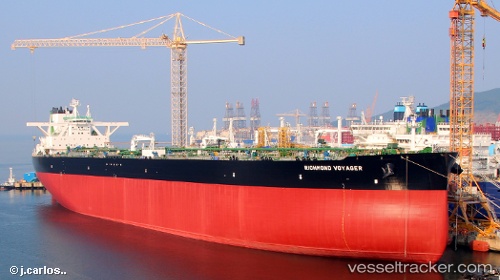
 RICHMOND VOYAGER
Current Status
Where is the vessel?
RICHMOND VOYAGER is currently in 229 nm W of Iba, based on AIS data received less than 1h ago.
Latest AIS update:
Current position: 14.71667° N, 116.07500° E (229 nm W of Iba)
Average speed (last 7 days): Loading…
Average speed (last 30 days): Loading…
Vessel profile: RICHMOND VOYAGER is a Tanker with dimensions m x m.
This page combines live AIS, route history, probable destination signals, nearby traffic, and port activity for practical vessel monitoring.
The current position of vessel RICHMOND VOYAGER is 14.71667 lat / 116.07500 lng. Updated: 2026-04-03 11:43:27 UTCNearest reference points:
- 222 nm W of Iba
- 282 nm E of Tan Cang Qui Nhon
- 237 nm W of Tindalo Oil Field
Currently sailing under the flag of Marshall Islands ![]()
Details:
Live Vessel RICHMOND VOYAGER Analytics (details, animations, etc.)
Recent AIS points (UTC):
2026-04-03 05:01:28 UTC · 13.35833, 114.97167 · SOG 15 kn · COG -1°2026-04-03 07:50:20 UTC · 13.92544, 115.42608 · SOG 15.2 kn · COG 38°
2026-04-03 09:34:34 UTC · 14.27167, 115.71333 · SOG 15 kn · COG -1°
2026-04-03 11:43:27 UTC · 14.71667, 116.07500 · SOG 15 kn · COG -1°