 vesseltracker.com
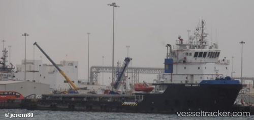
 AM POWER
Current Status
Where is the vessel?
AM POWER is currently in 77 nm S of Jafarabad, based on AIS data received less than 1h ago.
Latest AIS update:
Current position: 19.56038° N, 71.34824° E (77 nm S of Jafarabad)
Average speed (last 7 days): Loading…
Average speed (last 30 days): Loading…
Vessel profile: AM POWER is a Other Type with dimensions m x m.
This page combines live AIS, route history, probable destination signals, nearby traffic, and port activity for practical vessel monitoring.
The current position of vessel AM POWER is 19.56038 lat / 71.34824 lng. Updated: 2026-04-14 06:34:09 UTCNearest reference points:
- 33 nm S of Mul Dwårka
- 17 nm SE of Port Pipavav
- Near Jafarabad
Currently sailing under the flag of Marshall Islands ![]()
Details:
Live Vessel AM POWER Analytics (details, animations, etc.)
Recent AIS points (UTC):
2026-04-13 23:56:08 UTC · 19.57844, 71.23709 · SOG 1.6 kn · COG 93°2026-04-14 01:40:41 UTC · 19.56540, 71.30761 · SOG 4.5 kn · COG 85°
2026-04-14 03:31:40 UTC · 19.56530, 71.34487 · SOG 1 kn · COG 224°
2026-04-14 06:34:09 UTC · 19.56038, 71.34824 · SOG 1.3 kn · COG 301°