 vesseltracker.com
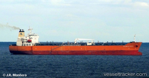
 SEAWAYS MIRAGE
Current Status
Where is the vessel?
SEAWAYS MIRAGE is currently in 65 nm W of Yof, based on AIS data received less than 1h ago.
Latest AIS update:
Current position: 14.67260° N, 18.57478° W (65 nm W of Yof)
Average speed (last 7 days): Loading…
Average speed (last 30 days): Loading…
Vessel profile: SEAWAYS MIRAGE is a Oil/Chemical Tanker with dimensions m x m.
This page combines live AIS, route history, probable destination signals, nearby traffic, and port activity for practical vessel monitoring.
The current position of vessel SEAWAYS MIRAGE is 14.67260 lat / -18.57478 lng. Updated: 2026-04-22 19:33:32 UTCNearest reference points:
- Near Dakar
- Near Rufisque
- Near Banjul
Currently sailing under the flag of Marshall Islands ![]()
Details:
Live Vessel SEAWAYS MIRAGE Analytics (details, animations, etc.)
Recent AIS points (UTC):
2026-04-22 16:08:13 UTC · 15.43905, -18.53130 · SOG 13.6 kn · COG 181°2026-04-22 18:20:31 UTC · 14.93860, -18.56683 · SOG 13.4 kn · COG 183°
2026-04-22 19:26:14 UTC · 14.69818, -18.58085 · SOG 13 kn · COG 172°
2026-04-22 19:33:32 UTC · 14.67260, -18.57478 · SOG 12.9 kn · COG 167°