 vesseltracker.com
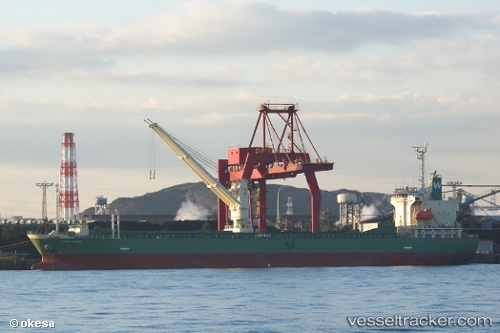
 WHITE INABA
Current Status
Where is the vessel?
WHITE INABA is currently in Near Yokohama, based on AIS data received less than 1h ago.
Latest AIS update:
Current position: 35.45183° N, 139.69070° E (Near Yokohama)
Average speed (last 7 days): Loading…
Average speed (last 30 days): Loading…
Vessel profile: WHITE INABA is a General Cargo Ship with dimensions 128m x 20m.
This page combines live AIS, route history, probable destination signals, nearby traffic, and port activity for practical vessel monitoring.
The current position of vessel WHITE INABA is 35.45183 lat / 139.69070 lng. Updated: 2026-04-06 00:00:56 UTCNearest reference points:
- Near Yokohama
- Near Kawasaki
- Near Naka-Ku, Kanagawa
Currently sailing under the flag of Philippines ![]()
WHITE INABA built in 2013 year
Deadweight:
13946 tDetails:
Live Vessel WHITE INABA Analytics (details, animations, etc.)
Recent AIS points (UTC):
2026-04-05 17:26:40 UTC · 35.45184, 139.69073 · SOG 0 kn · COG 300°2026-04-05 19:26:40 UTC · 35.45183, 139.69066 · SOG 0 kn · COG 300°
2026-04-05 22:17:40 UTC · 35.45183, 139.69069 · SOG 0 kn · COG 300°
2026-04-06 00:00:56 UTC · 35.45183, 139.69070 · SOG 0 kn · COG 300°