 vesseltracker.com
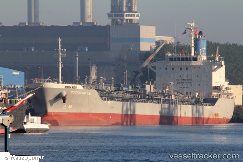
 SOUTHERN OWL
Current Status
Where is the vessel?
SOUTHERN OWL is currently in 111 nm E of Cabedelo Pt, based on AIS data received about 12h ago.
Latest AIS update:
Current position: 6.43894° S, 33.05598° W (111 nm E of Cabedelo Pt)
Average speed (last 7 days): Loading…
Average speed (last 30 days): Loading…
Vessel profile: SOUTHERN OWL is a Chemical/Oil Products Tanker with dimensions 149m x 25m.
This page combines live AIS, route history, probable destination signals, nearby traffic, and port activity for practical vessel monitoring.
The current position of vessel SOUTHERN OWL is -6.43894 lat / -33.05598 lng. Updated: 2026-04-10 07:13:11 UTCNearest reference points:
- 20 nm E of Natal
- Near Boa Viagem
- Near Suape
Currently sailing under the flag of Singapore ![]()
SOUTHERN OWL built in 2016 year
Deadweight:
26057 tDetails:
Live Vessel SOUTHERN OWL Analytics (details, animations, etc.)
Recent AIS points (UTC):
2026-04-10 02:04:18 UTC · -7.44903, -33.62275 · SOG 13.5 kn · COG 30°2026-04-10 03:24:15 UTC · -7.18836, -33.47555 · SOG 13.8 kn · COG 27°
2026-04-10 05:58:04 UTC · -6.68495, -33.19316 · SOG 13.7 kn · COG 29°
2026-04-10 07:13:11 UTC · -6.43894, -33.05598 · SOG 13.3 kn · COG 30°