 vesseltracker.com
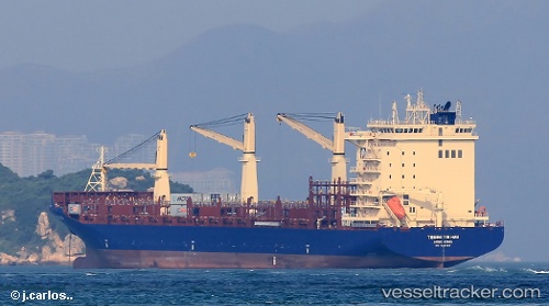
 MAERSK NUSANTARA
Current Status
Where is the vessel?
MAERSK NUSANTARA is currently in Near Nipah, based on AIS data received about 3h ago.
Latest AIS update:
Current position: 1.22036° N, 103.54553° E (Near Nipah)
Average speed (last 7 days): Loading…
Average speed (last 30 days): Loading…
Vessel profile: MAERSK NUSANTARA is a Container Ship with dimensions 186m x 186m.
This page combines live AIS, route history, probable destination signals, nearby traffic, and port activity for practical vessel monitoring.
The current position of vessel MAERSK NUSANTARA is 1.22036 lat / 103.54553 lng. Updated: 2026-04-10 08:09:07 UTCNearest reference points:
- Near Nipah
- Near Tuas
- Near JURONG ISLAND
Currently sailing under the flag of Singapore ![]()
MAERSK NUSANTARA built in 2016 year
Deadweight:
37056 tDetails:
Live Vessel MAERSK NUSANTARA Analytics (details, animations, etc.)
Recent AIS points (UTC):
2026-04-10 01:39:02 UTC · 1.69993, 104.71189 · SOG 12.4 kn · COG 220°2026-04-10 04:14:35 UTC · 1.32657, 104.33561 · SOG 13.9 kn · COG 230°
2026-04-10 05:56:34 UTC · 1.24102, 103.95781 · SOG 14 kn · COG 249°
2026-04-10 08:09:07 UTC · 1.22036, 103.54553 · SOG 10.4 kn · COG 306°