 vesseltracker.com
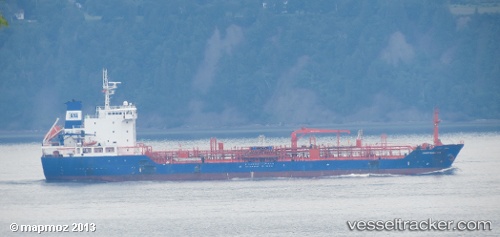
Ulaya
Current StatusWhere is the vessel?
Ulaya is currently in 114 nm SE of NISHINOOMOTE, based on AIS data received about 2h ago.
Latest AIS update:
Current position: 29.13793° N, 132.18521° E (114 nm SE of NISHINOOMOTE)
Average speed (last 7 days): Loading…
Average speed (last 30 days): Loading…
Vessel profile: Ulaya is a Chemical Oil Products Tanker with dimensions 20m x 129m.
This page combines live AIS, route history, probable destination signals, nearby traffic, and port activity for practical vessel monitoring.
The current position of vessel Ulaya is 29.13793 lat / 132.18521 lng. Updated: 2026-04-20 05:06:15 UTCNearest reference points:
- 107 nm NE of Kitadaito Apt
- 190 nm E of NISHINOOMOTE
- Near YAMAGAWA
Details:
Live Vessel Ulaya Analytics (details, animations, etc.)
Recent AIS points (UTC):
2026-04-20 00:42:17 UTC · 29.59517, 132.83011 · SOG 9.9 kn · COG 233°2026-04-20 00:42:17 UTC · 29.59517, 132.83011 · SOG 9.9 kn · COG 233°
2026-04-20 05:06:15 UTC · 29.13793, 132.18521 · SOG 11 kn · COG 236°
2026-04-20 05:06:15 UTC · 29.13793, 132.18521 · SOG 11 kn · COG 236°