 vesseltracker.com
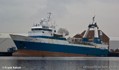
 Atlantic Peace
Current Status
Where is the vessel?
Atlantic Peace is currently in Near SALDANHA, based on AIS data received about 1193d ago.
Latest AIS update:
Current position: 33.02427° S, 17.95533° E (Near SALDANHA)
Average speed (last 7 days): Loading…
Average speed (last 30 days): Loading…
Vessel profile: Atlantic Peace is a Fishing Vessel with dimensions 57m x 13m.
This page combines live AIS, route history, probable destination signals, nearby traffic, and port activity for practical vessel monitoring.
The current position of vessel Atlantic Peace is -33.02427 lat / 17.95533 lng. Updated: 2023-01-10 18:24:50 UTCNearest reference points:
- Near Saint Helena Bay
- Near Laaiplek
- 12 nm W of ROBBEN ISLAND
Currently sailing under the flag of South Africa ![]()
Atlantic Peace built in 1987 year
Deadweight:
865 tDetails:
Live Vessel Atlantic Peace Analytics (details, animations, etc.)
Recent AIS points (UTC):
2023-01-10 18:24:50 UTC · -33.02427, 17.95533 · SOG 0.1 kn · COG 0°