 vesseltracker.com
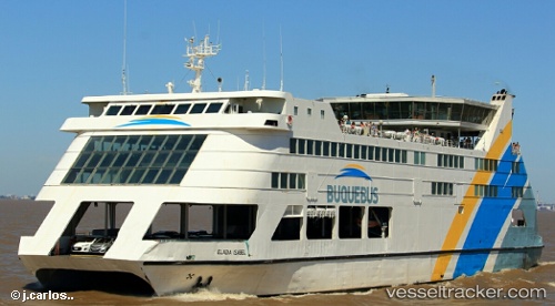
 ELADIA ISABEL
Current Status
Where is the vessel?
ELADIA ISABEL is currently in Near TUZLA, based on AIS data received about 23h ago.
Latest AIS update:
Current position: 40.83828° N, 29.28200° E (Near TUZLA)
Average speed (last 7 days): Loading…
Average speed (last 30 days): Loading…
Vessel profile: ELADIA ISABEL is a High speed craft with dimensions m x m.
This page combines live AIS, route history, probable destination signals, nearby traffic, and port activity for practical vessel monitoring.
The current position of vessel ELADIA ISABEL is 40.83828 lat / 29.28200 lng. Updated: 2026-04-10 07:40:07 UTCNearest reference points:
- Near TUZLA
- Near Tuzla Free Zone
- Near PENDIK
Currently sailing under the flag of Comoros ![]()
Details:
Live Vessel ELADIA ISABEL Analytics (details, animations, etc.)
Recent AIS points (UTC):
2026-04-10 02:13:09 UTC · 40.83826, 29.28201 · SOG 0 kn · COG -1°2026-04-10 04:04:07 UTC · 40.83827, 29.28202 · SOG 0 kn · COG -1°
2026-04-10 05:28:10 UTC · 40.83829, 29.28198 · SOG 0 kn · COG -1°
2026-04-10 07:40:07 UTC · 40.83828, 29.28200 · SOG 0 kn · COG -1°