 vesseltracker.com
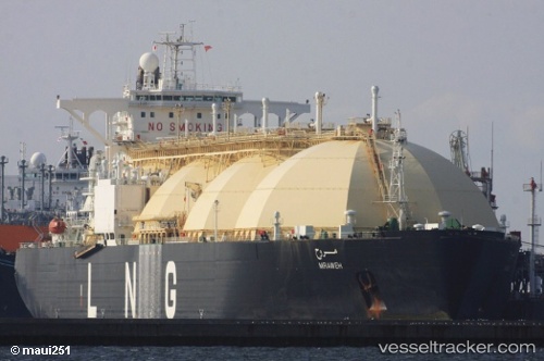
 Mraweh
Current Status
Where is the vessel?
Mraweh is currently in 28 nm SW of Bataduwa, based on AIS data received less than 1h ago.
Latest AIS update:
Current position: 6.00534° N, 79.68738° E (28 nm SW of Bataduwa)
Average speed (last 7 days): Loading…
Average speed (last 30 days): Loading…
Vessel profile: Mraweh is a Lng Tanker with dimensions 290m x 290m.
This page combines live AIS, route history, probable destination signals, nearby traffic, and port activity for practical vessel monitoring.
The current position of vessel Mraweh is 6.00534 lat / 79.68738 lng. Updated: 2026-04-01 01:59:15 UTCNearest reference points:
- 19 nm SW of Bataduwa
- 38 nm SW of Galle
- 15 nm S of Koggala
Currently sailing under the flag of Liberia ![]()
Mraweh built in 1996 year
Deadweight:
73040 tDetails:
Live Vessel Mraweh Analytics (details, animations, etc.)
Recent AIS points (UTC):
2026-03-31 19:18:24 UTC · 6.13500, 79.16500 · SOG 5 kn · COG -1°2026-03-31 21:33:29 UTC · 6.09333, 79.33500 · SOG 5 kn · COG -1°
2026-03-31 23:51:30 UTC · 6.04382, 79.52271 · SOG 5 kn · COG 104°
2026-04-01 01:59:15 UTC · 6.00534, 79.68738 · SOG 4.8 kn · COG 106°