 vesseltracker.com
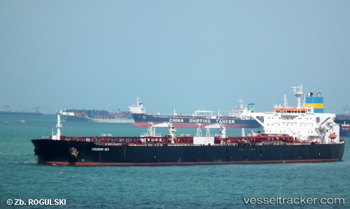
 Ligurian Sea
Current Status
Where is the vessel?
Ligurian Sea is currently in Near Saturna Island, based on AIS data received about 1h ago.
Latest AIS update:
Current position: 48.73468° N, 123.15322° W (Near Saturna Island)
Average speed (last 7 days): Loading…
Average speed (last 30 days): Loading…
Vessel profile: Ligurian Sea is a Crude Oil Tanker with dimensions 249m x 44m.
This page combines live AIS, route history, probable destination signals, nearby traffic, and port activity for practical vessel monitoring.
The current position of vessel Ligurian Sea is 48.73468 lat / -123.15322 lng. Updated: 2026-04-15 04:05:45 UTCNearest reference points:
- Near Deer Harbor
- Near FRIDAY HARBOR
- Near North Saanich
Currently sailing under the flag of Liberia ![]()
Ligurian Sea built in 2011 year
Deadweight:
116715 tDetails:
Live Vessel Ligurian Sea Analytics (details, animations, etc.)
Recent AIS points (UTC):
2026-04-14 19:28:53 UTC · 49.29194, -122.95381 · SOG 0 kn · COG 288°2026-04-14 21:46:51 UTC · 49.29196, -122.95382 · SOG 0 kn · COG 288°
2026-04-15 00:12:34 UTC · 49.32008, -123.24619 · SOG 11.8 kn · COG 256°
2026-04-15 04:05:45 UTC · 48.73468, -123.15322 · SOG 12 kn · COG 243°