 vesseltracker.com
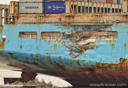
 MAERSK KALMAR
Current Status
Where is the vessel?
MAERSK KALMAR is currently in Near Ras Al Khor, based on AIS data received about 1d ago.
Latest AIS update:
Current position: 25.29127° N, 55.54015° E (Near Ras Al Khor)
Average speed (last 7 days): Loading…
Average speed (last 30 days): Loading…
Vessel profile: MAERSK KALMAR is a Container Ship with dimensions 42m x 299m.
This page combines live AIS, route history, probable destination signals, nearby traffic, and port activity for practical vessel monitoring.
The current position of vessel MAERSK KALMAR is 25.29127 lat / 55.54015 lng. Updated: 2026-04-04 22:06:42 UTCNearest reference points:
- Near Sharjah
- Near Al Hamriyah
- Near Mina Khalid
Currently sailing under the flag of Liberia ![]()
MAERSK KALMAR built in 1998 year
Deadweight:
94769 tDetails:
Live Vessel MAERSK KALMAR Analytics (details, animations, etc.)
Recent AIS points (UTC):
2026-04-04 21:47:59 UTC · 25.28511, 55.53773 · SOG 29.9 kn · COG 46°2026-04-04 22:06:42 UTC · 25.29127, 55.54015 · SOG 49.1 kn · COG 48°
2026-04-04 22:06:42 UTC · 25.29127, 55.54015 · SOG 49.1 kn · COG 48°
2026-04-04 22:06:42 UTC · 25.29127, 55.54015 · SOG 49.1 kn · COG 48°