 vesseltracker.com
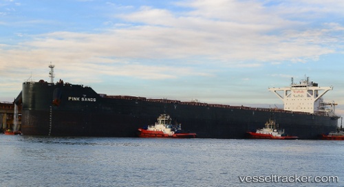
 PINK SANDS
Current Status
Where is the vessel?
PINK SANDS is currently in Near Shidao Pt, based on AIS data received about 9d ago.
Latest AIS update:
Current position: 36.83332° N, 122.27339° E (Near Shidao Pt)
Average speed (last 7 days): Loading…
Average speed (last 30 days): Loading…
Vessel profile: PINK SANDS is a Cargo with dimensions m x m.
This page combines live AIS, route history, probable destination signals, nearby traffic, and port activity for practical vessel monitoring.
The current position of vessel PINK SANDS is 36.83332 lat / 122.27339 lng. Updated: 2026-04-07 04:33:35 UTCNearest reference points:
- 12 nm W of Shidao Pt
- Near Shidao Pt
- Near SHIDAO
Currently sailing under the flag of Liberia ![]()
Details:
Live Vessel PINK SANDS Analytics (details, animations, etc.)
Recent AIS points (UTC):
2026-04-07 03:54:34 UTC · 36.83335, 122.27338 · SOG 0 kn · COG 358°2026-04-07 04:33:35 UTC · 36.83332, 122.27339 · SOG 0 kn · COG 358°
2026-04-07 04:33:35 UTC · 36.83332, 122.27339 · SOG 0 kn · COG 358°
2026-04-07 04:33:35 UTC · 36.83332, 122.27339 · SOG 0 kn · COG 358°