 vesseltracker.com
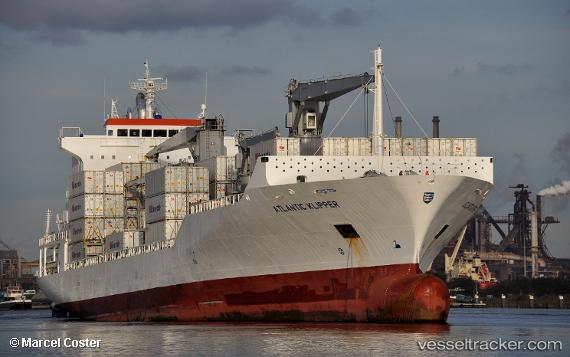
 ATLANTIC KLIPPER
Current Status
Where is the vessel?
ATLANTIC KLIPPER is currently in 304 nm E of La Désirade, based on AIS data received about 3h ago.
Latest AIS update:
Current position: 18.00176° N, 56.08471° W (304 nm E of La Désirade)
Average speed (last 7 days): Loading…
Average speed (last 30 days): Loading…
Vessel profile: ATLANTIC KLIPPER is a Reefer/Container Ship with dimensions m x m.
This page combines live AIS, route history, probable destination signals, nearby traffic, and port activity for practical vessel monitoring.
The current position of vessel ATLANTIC KLIPPER is 18.00176 lat / -56.08471 lng. Updated: 2026-04-13 13:18:13 UTCNearest reference points:
- 314 nm NE of La Désirade
- 267 nm E of La Désirade
- Open sea, approx. 401 nm off the nearest listed port
Currently sailing under the flag of Liberia ![]()
Details:
Live Vessel ATLANTIC KLIPPER Analytics (details, animations, etc.)
Recent AIS points (UTC):
2026-04-13 08:06:29 UTC · 19.25366, -55.04758 · SOG 18.3 kn · COG 219°2026-04-13 09:40:30 UTC · 18.87433, -55.34923 · SOG 18.1 kn · COG 218°
2026-04-13 11:43:42 UTC · 18.38095, -55.75676 · SOG 18.5 kn · COG 218°
2026-04-13 13:18:13 UTC · 18.00176, -56.08471 · SOG 18.9 kn · COG 218°