 vesseltracker.com
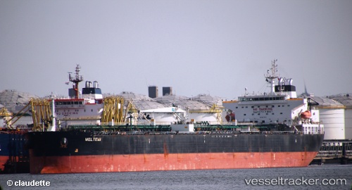
 Meltemi I
Current Status
Where is the vessel?
Meltemi I is currently in 235 nm SW of YORK, based on AIS data received about 1h ago.
Latest AIS update:
Current position: 5.21943° N, 15.63463° W (235 nm SW of YORK)
Average speed (last 7 days): Loading…
Average speed (last 30 days): Loading…
Vessel profile: Meltemi I is a Crude Oil Tanker with dimensions 50m x 274m.
This page combines live AIS, route history, probable destination signals, nearby traffic, and port activity for practical vessel monitoring.
The current position of vessel Meltemi I is 5.21943 lat / -15.63463 lng. Updated: 2026-04-07 05:27:58 UTCNearest reference points:
- 126 nm SW of YORK
- Open sea, approx. 405 nm off the nearest listed port
- Open sea, approx. 408 nm off the nearest listed port
Currently sailing under the flag of Liberia ![]()
Meltemi I built in 0 year
Deadweight:
0 tDetails:
Live Vessel Meltemi I Analytics (details, animations, etc.)
Recent AIS points (UTC):
2026-04-07 00:08:27 UTC · 5.20848, -15.60977 · SOG 0.3 kn · COG 278°2026-04-07 01:37:05 UTC · 5.21382, -15.61628 · SOG 0.2 kn · COG 266°
2026-04-07 04:07:56 UTC · 5.22045, -15.62950 · SOG 0.4 kn · COG 263°
2026-04-07 05:27:58 UTC · 5.21943, -15.63463 · SOG 0.2 kn · COG 265°