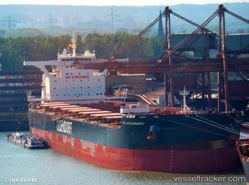
.
Vessel photo of William Oldendorff (IMO 9623570) vesseltracker.com

William Oldendorff

Vessel type: Bulk Carrier | IMO: 9623570 | MMSI: MMSI: 636092761
Call sign: D5NF7 | Dimensions: 45 m x 292 m
Current Status

Where is the vessel?

William Oldendorff is currently in 32 nm NW of Fahal, based on AIS data received about 2h ago.

Latest AIS update:

Current position: 24.10576° N, 58.13228° E (32 nm NW of Fahal)

Average speed (last 7 days): Loading…

Average speed (last 30 days): Loading…

Vessel profile: William Oldendorff is a Bulk Carrier with dimensions 45m x 292m.

This page combines live AIS, route history, probable destination signals, nearby traffic, and port activity for practical vessel monitoring.

The current position of vessel William Oldendorff is 24.10576 lat / 58.13228 lng. Updated: 2026-03-26 15:24:02 UTC
Nearest reference points:
  • 58 nm S of JASK
  • 42 nm SE of Offshore Fujairah
  • 17 nm SE of JASK
Details:

Live Vessel William Oldendorff Analytics (details, animations, etc.)


Recent AIS points (UTC):
2026-03-26 13:26:03 UTC · 24.23046, 57.70844 · SOG 12.5 kn · COG 118°
2026-03-26 15:24:02 UTC · 24.10576, 58.13228 · SOG 12.5 kn · COG 100°

Track of the vessel in the last 28 days


UTC: --
Start: -- Track timeline (UTC) End: --
Encountered: --


Link to the map:


Find another ship

William_Oldendorff (636092761) last ports (portcalls and passsages)

Tampines | 2025-09-08 11:06:16
Port Louis | 2025-08-25 19:36:04
SEPT-ILES | 2025-07-20 16:36:24
MUSEL ARNAO | 2025-07-08 08:37:03
MUSEL ARNAO | 2025-07-04 08:29:38
Strait Of Gibraltar | 2025-05-30 23:16:09
TARIFA | 2025-05-30 21:38:58
Algeciras | 2025-05-30 05:39:19
LUCIJA | 2025-05-19 00:12:39
MUGGIA | 2025-05-18 08:20:29
MUGGIA | 2025-05-14 07:32:17
MUGGIA | 2025-05-10 07:26:42
LUCIJA | 2025-05-10 05:54:40
Ceuta | 2025-05-02 23:32:44
TANGER MED | 2025-05-02 22:59:51
SALDANHA | 2025-04-10 11:22:14
Saldanha Bay | 2025-04-10 09:24:56
Cape Of Good Hope | 2025-04-04 06:42:53
Singapore | 2025-02-25 15:36:05
BATU AMPAR | 2025-02-25 15:21:11
TANAH MERAH | 2025-02-23 09:21:31
PENGERANG | 2025-02-23 08:10:07
Taboneo | 2025-02-16 08:06:49
Taboneo | 2025-02-12 07:49:13
Taboneo | 2025-02-08 07:21:35
Taboneo | 2025-02-04 06:13:46
Taboneo | 2025-01-31 05:20:13
Dalien | 2025-01-13 08:05:49
Dalien | 2025-01-09 07:55:38
Dalien | 2025-01-05 06:52:36
DONGJIAKOU | 2024-12-30 20:58:30
Newcastle | 2024-12-09 00:41:13
JINGTANG | 2024-11-03 16:16:12
Tsugaru-Kaikyo | 2024-10-18 06:58:14
Victoria | 2024-10-01 07:48:30
Vancouver | 2024-09-29 18:21:48
Vancouver | 2024-09-25 17:41:58
Tsugaru-Kaikyo | 2024-09-11 20:37:18
Singapore | 2024-08-07 04:18:38
Santa Marta | 2024-06-19 17:16:50
Cape Of Good Hope | 2024-05-28 18:27:34
Singapore | 2024-04-14 20:11:32
Port Louis | 2024-04-02 03:05:17
Santa Marta | 2024-02-26 20:44:48
Sambu | 2024-01-15 22:50:48
Singapore | 2024-01-12 20:44:22
Dagu Bar | 2023-12-24 15:12:10
Taku Bar | 2023-12-24 14:16:05
Selat Lombok | 2023-12-09 08:29:18
Port Headland | 2023-12-05 13:08:23
Selat Lombok | 2023-11-30 11:23:05
Selat Lombok | 2023-11-02 22:03:29
Port Headland | 2023-10-29 17:15:49
Selat Lombok | 2023-10-23 01:33:52
Lianyungang | 2023-10-10 09:24:41
Singapore | 2023-09-24 17:09:39
Ponta da Madeira | 2023-08-07 21:45:31
Sao Luiz | 2023-08-07 20:10:33
Sambu | 2023-06-28 00:49:52
Singapore | 2023-06-09 06:02:47
Sambu | 2023-02-19 08:28:36
Wusong | 2022-11-16 23:05:22
Singapore | 2022-10-30 23:49:53
Sao Luiz | 2022-09-10 16:39:43
Singapore | 2022-07-13 04:29:27
Port Louis | 2022-06-27 08:05:22
Singapore | 2022-04-15 21:16:42
Qingdao | 2022-03-13 03:28:07
San Nicolas | 2022-01-10 07:04:23
Taku Bar | 2021-12-06 22:19:34
Taku Bar | 2021-12-06 21:58:15
Dagu Bar | 2021-12-06 21:25:36
Taku Bar | 2021-12-04 23:01:00
Port Headland | 2021-09-30 16:02:23